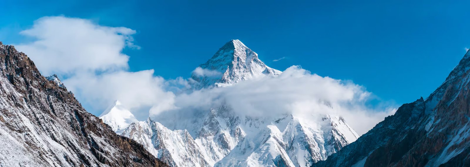
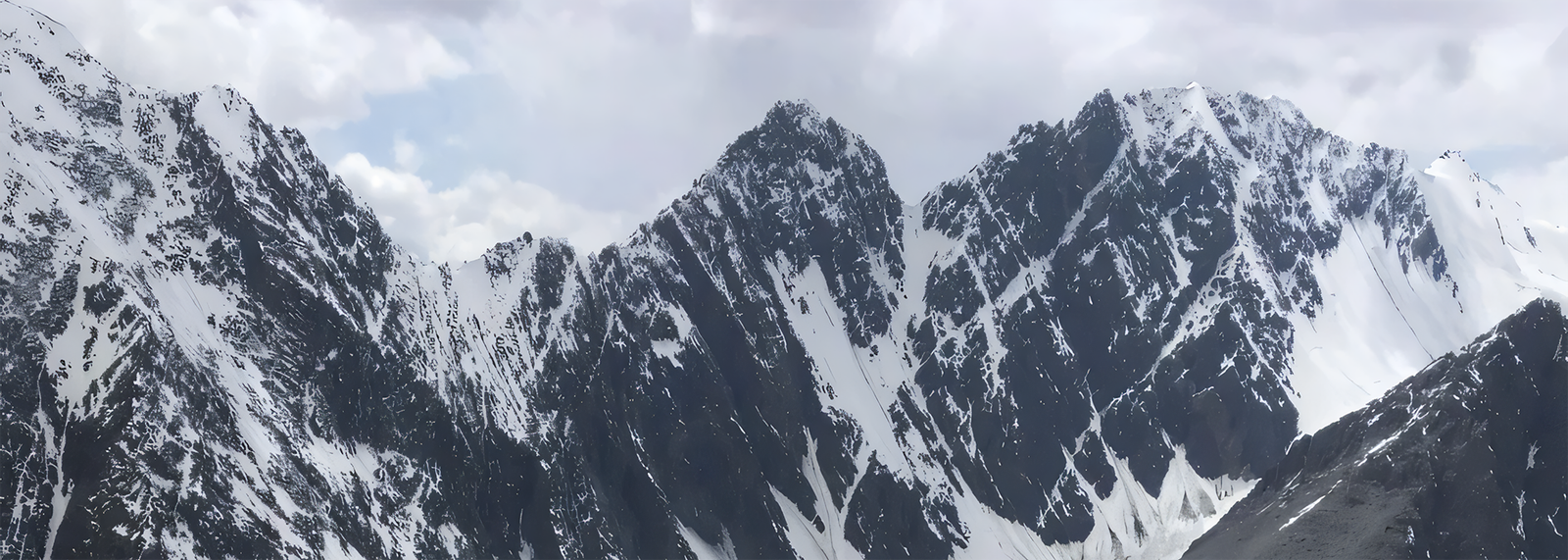
K2 (28,250 feet)
K2 the mountain of mountains, at 8,611m is the second highest peak after Everest. It is situated in the Karakoram mountains of Pakistan . It is a pyramidal peak, more beautiful than Everest and harder to climb. The traditional route to its base camp goes from Skardu, which is linked with the capital Islamabad both by road as well as by air . From Skardu the route goes via Askole up the Baltoro Glacier to Concordia .
History
In 1856 T.G. Montgomerie of the Royal British engineers established good relationship with Gulab Singh the ruler of Kashmir. He was thus given permission to carry surveys in remote corners of the state. During his surveys he marked a peak in the Karakorums as K1. ('K' standing for Karakorams). This was later identified as Masherbrum in Hushe valley in Khaplu area of Baltistan. He also saw another tall and dominating summit behind K1 and named it K2. The local name of K2 is Chogori, which in Balti language means the king of mountains, this name is little known in the outside world and it is popular as K2.
Accompaning Montgomerie on one survey was Captain Henry Haversham of the Survey of India . Captain Haversham Godwin-Austen had earlier surveyed Kajnag range in southern Kashmir and was the first to put Gulmarg on the map. In 1858-59, he surveyed eastern Kashmir including Jammu then in 1860 he went to Baltistan to survey Shigar and Saltoro valleys, in 1861 he went up the Braldu valley from Skoro-La (5,043m) surveying Chogo-lungma, Kero Lungma, Biafo and Panmah glaciers. It was from Kero Lungma that Godwin-Austen climbed the Nushik pass (4,990m) becoming the first to enter the 53-km-long Hispar glacier exploring Baltoro and Godwin-Austen glacier. It is however a myth that K2 , which was also referred to as Godwin-Austen peak, was discovered by him.
Another famous explorer of this region was Sir Francis Younghusband in 1887, he crossed Gobi desert from Peking and entered India by crossing Mustagh pass becoming the first European to observe K2 from the northern side.
In 1902, the first attempt to climb K2 was made by a multi-national expedition of experienced British, Austrian and swiss alpinist led by the Englishman Oscar J.L. Eckenstein. Traveling up the Boltoro glacier their approach climb was directly from the south over the south east ridge . After struggling up the Godwin Austin glacier they were forced to withdraw by heavy snow and harsh weather. They concluded that the north east ridge was probably much easier, information collected by them on the Godwin-Austen glacier was very helpful for later expeditions into the region. Two expedition members Dr. Jules Jacot Guillarmot swiss and Dr. V. Wesseley from Austria climbed to 6,523m on the north-eastern ridge of K-2. The party also ascended Skyang La (6,1 50m) .
In 1909 the brilliant explorer the Duke of Abruzzi Luigi Amadeo Giuseppe the grandson of King Victor Emmanuel II of Italy led a big Italian Scientific to K2 . Its members produced a very good account of the expedition with photographs and accurate maps of Baltoro area. The Duke, however, rejected the southern and western ridges of the mountain for a climb. His party attempted the peak from the south-east ridge-which later came to be known as Abruzzi ridge - but could not proceed beyond 5,560m/ because of porters problem. The party, however, carried out a thorough reconnaissance of K2 from south to north-east. Vittono Sella, a photographer and a climber, accompanied the Duke on this expedition. Sella pass, near Godwin-Austen glacier, is named after him.
Two famous British mountaineers, Harold William Tilman and Eric Earle Shipton, explored and surveyed the north face of K2 and its subsidiary glaciers in 1937. On a survey mission to Shaksgam valley they also visited the Trango and Sarpo Laggo glaciers and surveyed the famous Skamri glacier. Tilman was a famous explorer, mountaineer, sailor and writer. He also distinguished himself as a planter in Kenya. Shipton, on the other hand, was one of the significant explorers of the present century. He was Tilman's companion on most of the expeditions. Shipton was also Consul-General of India in Kashgar in 1940-42 and then in 1946-1948.
In 1938, the American Alpine Club sponsored a small but strong four member party on a reconnaissance to K2 . This was led by Charles Houston a Harvard educated medical doctor who two years previously had been on the successful expedition to Nanda Devi with Paul Petzoldt, a cowboy from Wyoming,. Six sherpas from Nepal were also on this expedition as porters led by the famous Pasang Kikuli. After a proper reconnaissance of the routes leading to K-2, the party rejected the north-west and north-east routes. Instead, it selected the south-east Abruzzi ridge.After establishing 8 camps, on 21 July two members Houston and Petzholdt reached a height of 7,925m . It was the shortage of food supplies that forced Houston and Petzoldt to return to lower altitudes. In the opinion of the party it was through this ridge that K2 peak could be climbed, which eventually proved correct.
In 1939, American expedition on K-2 led by Fritz Hermann Ernst Wiessner German-American chemist came within 750 feet of the submit but what could have been mountaineerings greatest triumph at that time unraveled into a disaster. Wiessner planned the expedition on a Spartan lightweight style refusing to bring oxygen even to base camp or walkie talkies on the mountain. Wiessner was an experienced climber since his teens and was acknowledged for conquering the hardest pure rock climbs in the Elbstiengebirge near the banks of river Elbe. Along with six members he was supported by 8 porters led by Pasang Kikuli . Wiessner followed the well tried route via the Abruzzi ridge and the southwest shoulder and by mid july had established and provisioned a chain of camps up to 7534m.. Two members and five sherpas set up camp VIII on the south-east ridge at about 7,711 m and left one member by the name of Dudley Wolfe in this camp as he had fallen sick. On 19 July, Wiessner, along Pasang Lama, went up to approximately 8,382m with K2 almost in their grasp. Deciding not to spend the night in the open they descended to attempt the climb next day.
On their way down Pasang lama lost the crampons so they had to descend further to restock themselves and bring Wolfe to camp V11 In search of food they came lower but found to their horror all camps abandoned until they reached camp II. There seems to have been a complete break down in understandings leading to panic and unnecessarily abandoning of camps. Immediately three sherpas were sent to rescue Wolfe, they never returned thus Wolfe and the sherpas perished on K2.
Another American attempt on K2 was made in 1953 and failed. The expedition leader was Dr. Charles Houston, who had also led the 1938 American expedition on this peak. Dr. Houston, a medical professor, is noted for his contribution and research on the effects of high altitude on human body and diseases originating from such effects. This time the party took porters from Hunza instead of sherpas from Nepal.
The expedition started late and by 01 August had finally established the high camp near the base of the final pyramid at 7772m , stockpiled it with sufficient food for 12 days and man it with skilled climbers. Success seem certain.Then a blizzard set in and continued unabated day after day which confined them to their tents for 6 days.. Soon one of the climbers Arthur Gilkey, developed thrombo phlebitis . They realized that the one hope of keeping him alive was to descend quickly to camp VII the higher camp needed to be restocked too. While descending the group miraculously escaped a fall. Gilkey was then secured on the snow slope with ice axes until a party could be mustered to bring him down. By the time help was mustered an avalanche swept away Gilkey. With casualties and frost bites the expedition abandoned all thought of the summit.
In 1954, an Italian expedition came to Pakistan to try its luck on K2. It consisted of twelve climbers and four scientists and was led by veteran mountaineer, Professor Ardito Desio, who had come to these mountains with Italian expeditions before the World War II.
The expedition reached Concordia in early june and were greeted with 40 days of non stop storm, their porters deserted , and one of their finest climbers, Mario Puchoz, died of pneumonia. The omen was not propitious but by end July camp 1 to 1X were established on the Abruzzi ridge till 7700m. They established an even further camp at the foot of the final pyramid from where on the 31st July, Lino Lacedelli and Achille Compagnoni launched their assault. 500 ft short of the summit they exhausted their oxygen supply but continued, it was 6 pm when they reached the summit. They remained at the top for half an hour by the time they started down, night was falling . They then realized that descending was more difficult than the ascend. During the descend they fell many times and with bruises, badly frost bitten and in last stages of exhaustion they finally reached the foot of the Abruzzi ridge having conquered what many climbers regard as the most formidable of the giants. The story of the climb has been narrated by Professor Desio in his book. "Victory over K-2" .
Itinerary . Flexible expeditions itineraries are made by us looking at your requirements and demands.
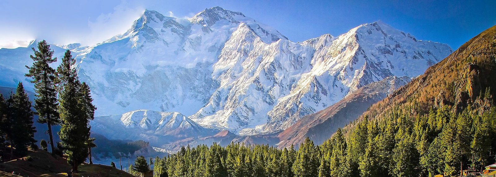
Nanga Parbat (26,660 feet)
Nanga Parbat is the most westerly buttress of the Himalaya, divided from the Hindukush by the gorge of the Indus. It is 8126m in height and when viewed from the west, is probably the most spectacular mountain on earth, for it rises near-sheer from the bed of the Indus for 7015 m of vertical height , 4 & half miles plunging, to all intents and purposes, vertically from the summit ridge, down through fields of ice and snow, down precipices and glaciers, down overhangs and rock-walls, down through scrub and scree and into a gorge which is 100 times more terrifying than the Grand Canyon a suffocating, rock-bound desert, where nothing grows and nothing lives, and the gneiss disintegrates in an average summer temperature of over 120F (49C). This, as Vigne wrote 150 years ago, 'is the most awful and most magnificent sight to be met with in the Himalayas.' Nanga Parbat or "Nanga Parvata" means the naked mountain. Its original and appropriate name, however, is Diamir the king of the mountains. Nanga Parbat has always been associated with tragedies and tribulations until it was climbed in 1953. A lot of mountaineers have perished on Nanga Parbat since 1895. Even today it is claiming a heavy toll of mountaineers becoming victims in their pursuit to its summit.
Nanga Parbat was the first of the 8000m peaks to be attempted. In 1895, three experienced British alpinists A. F .Mummery, Hastings and Norman Collie, together with a Gurkha officer Major Bruce accompanied by two of his regiment, surveyed the southern and western slopes up to the Bazhin glacier. The slopes offered little prospects of success. Mummery, therefore, proposed to cross the high ridge running north-west from the summit During the expedition Collie & a Gurkha were taken ill and Bruce's leave expired. The attempt on the summit was therefore abandoned, and the party split up, Collie and Hastings descending via the route up which they had come, while Mummery and the Gurkhas decided to reconnoiter a col a little to the east. On 24 August the three men set out for the col and were never seen again assumed swept by an avalanche. The killer mountain had struck it first tragic blow, other and greater tragedies were to follow.
Thirty seven years later, in 1932 a German-American team under Willy Merkl made a determined assault which, although it did not succeed, managed to pioneer a possible route through the Rakhiot glacier to the summit and could go till 7100m. Merkl's team consisted of climbers who had plenty of alpine but little Himalayan experience to organize the transport and liaison with the porters. Difficulties with the porters and unfavourable weather conditions made it impossible to progress, and they retreated
The German-Austrian expedition of 1934 was one of the largest ever to tackle major peak: nine experienced climbers, three scientists, two transport officers, 3 experienced Sherpas, and no fewer than 500 porters. By early June, four glacier camps had been established and provisioned. Everything seemed organized for an early attempt on the summit. Then came an unexpected tragedy. Alfred Drexel caught a chill, the chill turned to pneumonia, his condition rapidly deteriorated and he died of oedema of the lungs. The mountaineers and porters were then called back from climbing operations to the base camp for Drexel's funeral. Eleven cloudless days went by spent in the base camp due to the funeral and porters food not reaching the base. It therefore looks as though there must have been yet another misunderstanding between climbers and porters.
Finally the climbing resumed and the lead climbers reached the north-east summit of Nanga Parbat . On the morning of 6 July, five climbers and II Sherpas were poised for the final assault from Camp VIII, on the saddle at 7854m beneath the summit all within their grasp just 275 m away. Had the fittest of the five climbers attempted Nanga Parbat that afternoon, the first 8000m peak would almost certainly have been climbed. But Merkl wanted all five of his team members to reach the summit together; so they waited, to give the more exhausted climbers a chance to recuperate, confident that the next day would bring success for them all. Instead it brought the monsoons and bad weather set in for days. It seems the 11 clear days unnecessarily lost at base camp were to lead to one of the most terrible disasters in the history of mountaineering.
The weather remained bad for nine consecutive days with blizzards and snow storms, when it cleared, three climbers Merkl, Welzenbach, Wieland, and six sherpas had died slowly and painfully, huddled together in tents or ice-caves which became their graves. There have been alpine disasters of greater magnitude - whole expeditions snuffed out by some catastrophic avalanche - but none of such protracted horror: nine days of long, slow, agonizing death from cold, exposure and starvation.
In 1937 the Germans again laid seige to Nanga Parbat. The expedition led by Karl Wien had seven experienced climbers, , two scientists, a doctor, a cartographer, a transport officer, 12 experienced porters from Darjeeling and a number of carefully selected Baltis for work in the lower camps. Everything went fine and camp IV was set below the Rakhiot peak, when a terrible avalanche struck the camp and buried all the seven climbers and nine sherpas . The killer mountain had taken 16 lives within seconds.
The German Himalayan expedition of 1938 was led by Paul Bauer. The party did not achieve anything substantial and went home safely. However, this expedition had its moment of sorrow when at 7,000m it found several bodies from the 1934 disaster including Willy Merkls some frozen solid in snow caves, others hanging from fixed ropes on the ice-wall.
In 1939, a German expedition visited Nanga Parbat which was not really an assault but more of a reconnaissance of the Diamer rock face which had defeated Mummery. It was led by Peter Aufschnaiter. They found the rock face technically difficult and highly dangerous with vertical and unstable walls swept by avalanches. In the face of great difficulty and constant danger, they managed to just reach 6009 m before 'retreating . Their return to India coincided with the outbreak of World War II and they were interned. They managed to escape to Tibet staying at Lahsa with the Dalai Lama related in a travel classic "Seven years in Tibet"
In 1950, a party of three Englishmen, led by J.W.Thornley, made a winter attempt on the mountain through the Rakhiot face. This time the "killer" mountain claimed a toll of two lives.
In 1953 an Austro German expedition was organized by Dr. K.M. Herligkoffer step brother of Willy Merkl, it was led by Peter Aschen brenner. The expedition ran into all sorts of delays with doubts, opposition, lack of funds , late start .
They established camp V at 6,900m, on the north-east ridge between Rakhiot peak and Silver Saddle the weather was poor; it looked as though the monsoon was breaking early, and on 29 June Aschenbrenner gave the order to abandon the few camps which had been set up, and withdrew calling of the expedition.
There were, however, a handful of men unwilling to give up so easily. And four of them- Buhl, Ertl, Frauenberg and Kempter- refused to obey their leader's instructions to come down. They argued over the radio, there was still a chance. In answer to their prayers, a spell of clear weather followed.
The four men decided to 'go it alone'. They climbed swiftly to Camp V; and by the evening of 2 July, Buhl and Kempter were a little below the Silver Saddle, ready for an attack on the summit still 4000 feet (1220 m) above knowing no matter how early they started and how easy the climb, they could not get there and back in a single day realizing at around 7625 m they would have to spend a night in the open, without tents.
It was the sort of risk that most mountaineers would have thought unacceptable. Buhl set out next morning at the unlikely hour of 1.00 a.m.! Kempter tried to follow a couple of hours later but had to give up. It was now a case of one man, against all the odds, taking on Nanga Parbat alone.
Buhl made steady progress by moonlight but the sun, when it rose, was almost unbearably hot and he suffered badly from lassitude. At midday he cached his rucksack, food and spare pullover on the subsidiary summit 7915 m. So far the ascent had presented no problems - but the final stage turned out to be not so easy - a steep rock face with its south face falling sheer 4270 m to the valleys at Buhl's feet. It was 6.00 p.m. before he came to the last gendarme: 'a massive obstruction which had to be traversed with great care. I scrambled up it on all fours- I could climb it no other way- and suddenly realized I was able to go no higher. I was on the summit!'
After taking the mandatory photographs, he began what he must have known was a race with death, 'for already the sun was disappearing below the horizon.
The events of the next few minutes could have been fatal. First, in a state of forgetful euphoria, he left his ice-axe on the summit. Then, halfway down a precipitous ice-slope, his right crampon slipped off his boot, 'leaving me standing like a stork on the smooth, hard ice in one crampon, supporting myself as best I could with my ski-sticks, and with no idea of how to extricate myself.' Somehow, he managed to inch his way to safety, Half an hour later it was dark.
Buhl spent the night - incredible as it sounds - standing on a wobbly block of stone in the middle of a steep rock face. There was not enough level ground for him to crouch, let alone to sit all night he had to hang on to the rock face with one hand and his ski-sticks with the other, and he had nothing - not even a pullover - to keep him warm. All this was at a height of more than 7930 m.
Itinerary . Flexible expeditions itineraries are made by us looking at your requirements and demands.
For Broad Peak 8047m, Distaghil 7885 m, Kunyang Chhish 7852m, Masherbrum 7,821 m, Rakaposhi 7,788 m, Batura 7,785 m, Kanjut Sar 7,760 m, Chogolisa 7,665 m,and other major 7600 & 6000 peaks in the Karakorum Himalayas contact our office for details.
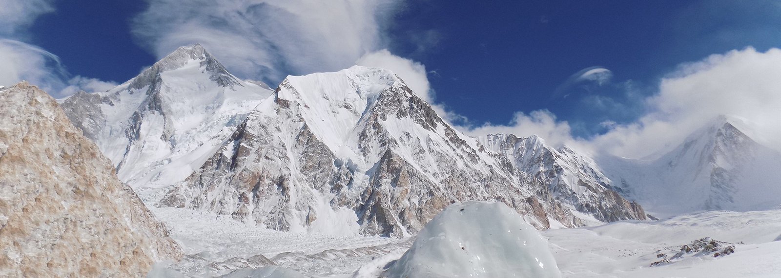
Gasherbrum (26,510 feet)
Gasherbrum in local language means "Shining Wall". There are six Gasherbrum Peaks. Gasherbrum I, also known as Hidden Peak 8,068m, is the highest peak among them. In 1936 the French Alpine Club planned an expedition which consisted of 10 members led by M. De Segogne . The expedition left Sirinagar by end of April with 500 porters and established base camp on 26 May at the foot of the golden Throne up at the end of the Baltoro glacier. To avoid the avalanche on the long steep snowfields a difficult route for the climb was planned to the south peak of the mountain, thence along an almost level razor backed ridge for a mile and up the pyramid peak itself. The climb throughout was thus slow and fixed ropes were mostly used, they could not climb beyond Camp V at a height of 6,797 m as the weather set in too early and attempts were aborted. In 1958 an American Expedition led by Nich Clinch made the first ascent of Gasherbrum I. Schoening and Kaufman were first to reach the summit. The approach route to Base camp starts from Skardu through Shigar Valley and approach trek starts from Askole through Baltoro glacier.
Gasherbrum II The shining mountain on the Karakoram range is just second highest peak among the Gasherbrum Peaks with an altitude of 8,035m/. The first ascent was made by Austrians led by Fritz Moravec along with Josef Larch and Hans Willenpart on 8th July, 1956. They set up a base camp on the south Gasherbrum glacier. Camp I was set up at at 6,005m/. It was here that the party was forced to stay for ten days because of a severe storm. Consequently, they lost a large supply store in an avalanche. After setting up a few more camps, Fritz Moravec, Josef Larch, and Hansenpart set up a bivouac below 7,620m/. inspite of frostbites suffered in the bivouac, the three reached he summit of Gasherbrum II on 8th July and came back without meeting any further accident.
The climb on this peak is both on rock and ice. A high level of technical skill, physical fitness and acclimatization is required. The approach to basecamp is via Skardu and about a week trek on Baltoro Glacier.
Gasherbrum III Gasherbrum III is situated between Gasherbrum II and IV and has a height of 7,952m/. It was the highest unclimbed peak upto 1974, before a polish ladies expedition, under the leadership of Mrs. Wanda Rutkiewics, climbed it on 11th August, 1975. The leader, along with Alison Chadwick, Janusz Onyszkiewicz and K. Zdzitowiecki, reached the top. The party claims that it was an all ladies expedition. It had, however, quite a few men probably to give moral support to the ladies , if and when needed, during the climb.
Itinerary . Flexible expeditions itineraries are made by us looking at your requirements and demands.
For Broad Peak 8047m, Distaghil 7885 m, Kunyang Chhish 7852m, Masherbrum 7,821 m, Rakaposhi 7,788 m, Batura 7,785 m, Kanjut Sar 7,760 m, Chogolisa 7,665 m,and other major 7600 & 6000 peaks in the Himalayas contact our office for details.
Tirich Mir (25,289 feet)
The Tirich Mir is a chain of about eleven peaks with different routes to their submits.
Tirich Mir main peak 7,708m is the highest peak of the Hindukush Mountain range and was first climbed in 1950 by a Norwegian expedition which was lead by Arne Naess. the famous Norwegian philosopher, other expedition members were P. Kvern berg and H. Berg.
Tirich Mir East with a height of 7,692m was another first Norwegian ascent done later in 1964 . Two members, R. Hoibakk and A. Opdal, reached top of Tirich Mir East
Tirich Mir West II , 7,500m was climbed in 1974 by Beppe Re and Guido Machetto of an Italian expedition. After establishing base camp, the party set up two additional camps. In order to acclimatize itself with high altitude climbing, the party also climbed an already-climbed Dir gol Zom peak.
On July 20 1967 Tirich Mir West I , 7487m was climbed through the north west col by a Czechoslovak expedition led by Engineer Vladimir Sedovy. J. Cervinka, I. Galfy, V. Smida and I. Urbanovic reached the top. The Czech expedition had not a single oxygen flask nor did they fix ropes.
Tirich Mir West III 7,400m was climbed in 1974 by Groupe Universitaire de Montagne et de Ski of France and was led by Guy Lucazeau and Bernard Amy. The sixth peak of the Tirich Mir range is Tirich Mir West IV - 7,338m. It was climbed in 1967 by Kurt Diemberger and Dietmar Proske through the very difficult north face. Diemberger also made the first circle around the Tirich Mirs. The purpose was to carry-out geological survey of the area.
Another interesting peak in the Tirich Mir range is un-named with a height of 7,100m. This peak is situated to the south of Tirich Mir Main peak.. The northern spur of Tirich Mir at 7,056m was climbed in 1965 by Kurt Diemberger, Herwig Handler and Fritz Lindner of a German - Austrian expedition.
Tirich Mir Little 6,550m was climbed in 1969 by the British-Pak Army Mountaineering expedition which was led by Maj. J. W. Fleming of the British Army.
ROUTE
Expedition to the main peak traverse the Lower Tirich Glacier which later branches out into upper and lower Tirich glacier. Base camp is set at Babu camp 4724m named after Babu Hindukush Trails famous local guide still around. The jeep road goes as far as Shahgrom 2760m but an alternate route over Zani pass 3840m is an excellent way to do a short trek to Shahgrom both to acclimatize and get a good perspective of the major peak before you reach Shahgrom.
While other expedition are attempted through the Norwegians route via Barum village into the upper Barum glaciers
Itinerary . Flexible expeditions itineraries are made by us looking at your requirements and demands.
For Istro-Nal. 7,403 m, Saragharar 7,349 m and other major peaks in the Hindukush & hindu Raj contact our office for details.
Noshaq (24,580 feet)
At 7492m Noshaq is the fourth highest peak of the Hindukush range . The mountain has four separate peaks . The main peak was climbed in 1960 along the south east ridge from the Qadzi Deh glacier by a Japanese expedition led by Professor Sakato. Other members of the expedition were G. Iwatsabo and T. Sakai.
The second highest peak in this range is Noshaq East at 7480m climbed in 1963 by Dr Gerald Gruber and Rudolf Pischinger from Austria. The third highest peak of the range Noshaq Central is 7400m . The Austrian expedition of 1963 of Dr Gerald Gruber and Rudolf Pischinger are also credited with climbing the fourth peak of Noshaq range called Noshaq West at 7250m.
The Afghan route follows the west ridge from where it is a relatively straightforward ascent and a Polish expedition in 1973 made the first winter ascent successfully. During the Russian war the low Sad Istragah pass was used as a mujahedin supply route and some of the adjoining areas around Qazi Deh was heavily mined which otherwise make it a potential risk route. Nowadays, the normal route is by Pakistan as arrangement in Pakistan follow a steady ploicy of regulation which has now considerably eased out also the route being techinical makes it all the more tough and interesting.
ROAD ROUTE Across the Lowari pass to Chitral town , take time to see the Kalash valleys. Then the jeep road goes as far as Shahgrom but an alternate route over Zani pass is an excellent way to both acclimatize and get a good perspective of the major peak before you reach Shahgrom.
CLIMBING ROUTE The peak is accessible through both Pakistan & Afghanistan as it is right on the border.
Logistically the route through Pakistan is more convenient as things are organized at this end. You follow the Tirich Mir route through the Lower & upper Tirich glaciers to Babu camp where you have views in all direction like Concordia. From here you branch out from the upper Tirich glacier in a different direction crossing a moraine between two icefalls then climb scree slopes to the south ridge. The two ice falls flowing from Noshaq make it a technically difficult ascent from this side , three camps are established before final ascent is made.
Alternately the other route through Afghanistan is from Badakshan & Wakhan . Though we have been organizing things in this area for the last 12 year but logistically its quite demanding. Approaching the peak through Afghanistan cost wise will be more expensive as Afghanistan is still in the process of settling down and stabilizing, one has to " constantly relocate connection over there !.
Itinerary . Flexible expeditions itineraries are made by us looking at your requirements and demands.